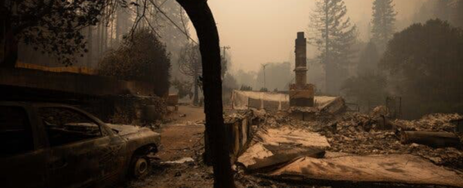
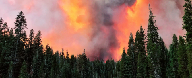
PHOTOS FROM THE FIELD: Week of September 21 – 25, 2020

PHOTOS FROM THE FIELD

Reuters—How wildfires ravaging the U.S. West Coast are sending smoke between continents and up to record heights in the atmosphere

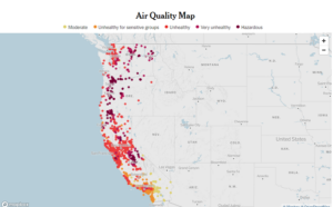
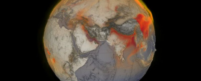
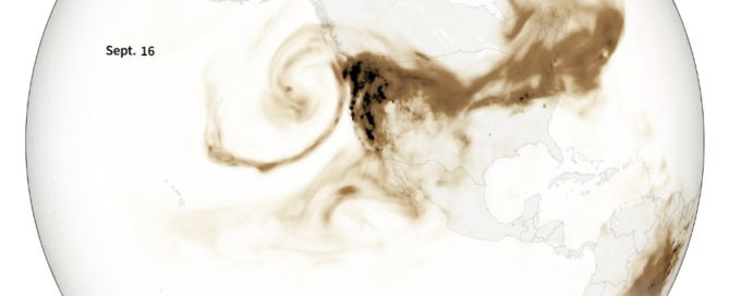
Last week, smoke from the fires covered the entire U.S. West Coast before spreading west out over the Pacific Ocean. This week the smoke has travelled thousands of miles east, turning skies from New York to Washington D.C. hazy and reaching as far as the skies above Britain.

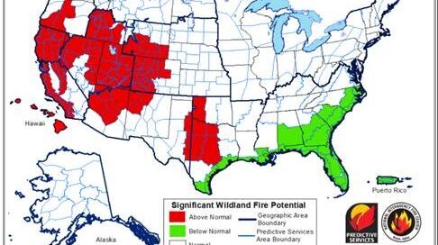
In the animation above, Reuters visualises organic carbon released into the atmosphere during the fires. The smoke contains a substantial portion of fine particulate matter known by the particles’ size as PM2.5, which can have a major impact on people’s health. Continue reading here.

2020-09-23T17:21:43+00:00September 23rd, 2020|PHOTOS FROM THE FIELD|

PHOTOS FROM THE FIELD: Week of September 14- 18, 2020

PHOTOS FROM THE FIELD

New York Times – California, Oregon and Washington Fire and Air Quality Maps

California, Oregon and Washington are enduring a wildfire season of historic proportions. More than two dozen people have died since early September, when powerful winds helped spark fires and propel existing ones, leaving millions of acres charred and thousands of structures destroyed. See the live coverage here.

Featured photo: The remains of a home were surrounded by smoke after it was destroyed by the Bear Fire in Berry Creek, Calif. Photo by Christian Monterrosa for The New York Times.

Left photo: Sensor data from PurpleAir. Readings have been adjusted to better account for the properties of wood smoke. The levels on the map are based on the air quality index, a measure of how clean or unhealthy the air is.

2020-09-16T16:39:37+00:00September 16th, 2020|PHOTOS FROM THE FIELD|

PHOTOS FROM THE FIELD: Week of September 7 – 11, 2020

PHOTOS FROM THE FIELD

USA Today – ‘Unprecedented’ wildfires burn across West: California firefighters injured, Oregon residents flee flames

More than 90 major fires that have burned more than 5,300 square miles – almost the size of Connecticut – are raging in 13 Western states, according to a count by the National Fire Information Center. Thick smoke obliterated the sun in some areas, distant flames turning the sky orange in others. Continue reading…

Photo from the field: Smoke from the Creek Fire billows beyond a ridge as seen Sept. 5 from Huntington Lake, Calif. (Eric Paul Zamora/Fresno Bee/AP)


2020-09-09T18:18:39+00:00September 9th, 2020|PHOTOS FROM THE FIELD|

PHOTOS FROM THE FIELD: Week of August 31 – September 4, 2020

PHOTOS FROM THE FIELD

National Interagency Coordination Center –

National Significant Wildland Fire Potential Outlook

The National Significant Wildland Fire Potential Outlook provides outlooks for the current month, the month following and a seasonal look at the two months beyond that. The main objective is to improve information available to fire management decision makers.  These assessments are designed to inform decision makers for proactive wildland fire management, thus better protecting lives and property, reducing firefighting costs and improving firefighting efficiency. The linked maps represent the cumulative forecasts of the eleven Geographic Area Predictive Services Units and the National Predictive Services Unit. Products are updated on the first of each month. A cursory overview shows that areas with an above normal wildfire potential overlap 169 tribal areas for September 2020.

2020-09-02T17:32:43+00:00September 2nd, 2020|PHOTOS FROM THE FIELD|

PHOTOS FROM THE FIELD: Week of August 24 – 28, 2020

PHOTOS FROM THE FIELD

NPR—To Manage Wildfire, California Looks To What Tribes Have Known All Along
The arrival of Western settlers dramatically changed the fire regime.
“They came with their concepts of being afraid of fire,” Goode says. “They didn’t understand fire in the sense of the tool that it could be to create and what it did to help generate and rejuvenate the land. So they brought in suppression.”
“We don’t put fire on the ground and not know how it’s going to turn out,” Ron Goode, tribal chairman of the North Fork Mono, tells the group. “That’s what makes it cultural burning, because we cultivate.”

Photos from the Field: Ron Goode, tribal chairman of the North Fork Mono, looks on as sourberry bushes burn. After the bushes are burned in the winter, they sprout again in the spring. Photo credit: Lauren Sommer/NPR


2020-08-26T17:30:10+00:00August 26th, 2020|PHOTOS FROM THE FIELD|

PHOTOS FROM THE FIELD: Week of August 17 – 21, 2020

PHOTOS FROM THE FIELD

NY Times—Trump Administration Finalizes Plan to Open Arctic Refuge to Drilling

The decision sets up a fierce legal battle over the fate of a vast, remote area that is home to polar bears, caribou and the promise of oil wealth.

Photo credit: Christopher Miller for The New York Times)


2020-08-19T18:08:27+00:00August 19th, 2020|PHOTOS FROM THE FIELD|

PHOTOS FROM THE FIELD: Week of August 10 – 14, 2020

PHOTOS FROM THE FIELD

American Lung Association in Montana Screening and Discussion of Unbreathable: The Fight for Healthy Air

Please click this URL to join! Wednesday, August 19, 2020; 12pm MDT

Created by American University’s Center for Environmental Filmmaking in partnership with the American Lung Association, this short film looks back on 50 years of the Clean Air Act, highlighting both the incredible progress made in cleaning up air pollution as well as the stories of communities that are still suffering from polluted environments. Underscoring the challenges we continue to face in protecting health and ensuring health equity amid the growing threats from climate change and worsening air quality, this 30-minute film premiers at a critical time. Asthma is the number one health issue for children, and recent research links air pollution to higher cases and deaths from COVID-19. Environmental regulations and enforcement of existing laws are being stripped away when the need for renewable energy is more urgent than ever.

We invite you to watch the film in advance and then join us live on Wednesday, August 19, 2020; 12pm for a moderated panel discussion. Registrants will be sent more instructions about how to view the film a few days before the event.

Special guests
• Kenneth Smoker, Jr., MBA, Director of Health Promotion and Disease Prevention Wellness Program, Fort Peck Tribes
• Gwen Lankford, Sapphire Strategies, Inc., specializing in strategic communications with a focus on health and climate; Member of the Gros Ventre Tribe and direct descendent of the Salish Tribe.
• Margaret Cook-Shimanek, MD, Occupational and Environmental Medicine Specialist
• Wilmot Collins, Mayor of Helena, MT
• Samantha Francine, Black Lives Matter Community Leader, Whitefish MT


2020-08-12T18:20:51+00:00August 12th, 2020|PHOTOS FROM THE FIELD|

PHOTOS FROM THE FIELD: Week of August 03 – 07, 2020

PHOTOS FROM THE FIELD

Fishing towns hoping they could dodge the coronavirus bullet got a wake-up call this month.

Until two weeks ago.

That’s when cases at fish processing plants began shooting up from a few dozen to more than 360, with spikes in Seward, Juneau and Anchorage, plus an outbreak aboard a factory trawler on the Aleutian Island chain.

In the state’s largest city, things are expected to worsen.

“With so many workers now testing positive, it is likely that this outbreak has been in progress for some time and that transmission has already occurred among family, friends and others in the community,” Dr. Bruce Chandler, the Anchorage health department’s chief medical officer, said in a statement. Continue reading

Indian Country Today – COVID spikes at Alaska fish processing plants raise alarm

Photo credit: Men unloading fish that had been iced down to stay chilled, Cordova. (Photo by Brandon Blake, Copper River Seafoods)


2020-08-05T17:46:02+00:00August 5th, 2020|PHOTOS FROM THE FIELD|

PHOTOS FROM THE FIELD: Week of July 27 – 31, 2020

PHOTOS FROM THE FIELD

This webinar was scheduled for Wednesday, July 29, 2020 at 2pm ET. The webinar provided Tribal officials and professionals with an Overview of COVID in the Workplace and Funding for Tribes, as Tribes consider opening public spaces safely. More information will be sent out in the coming days but if you have questions, please contact Andy Bessler.

To see the webinar recording, click here!


2020-07-29T20:38:01+00:00July 29th, 2020|PHOTOS FROM THE FIELD|

PHOTOS FROM THE FIELD: Week of July 20 – 24, 2020

PHOTOS FROM THE FIELD

Global emissions of the potent greenhouse gas methane hit an all-time high in 2017, according to a pair of new studies released this week by researchers with the Global Carbon Project. Agriculture, landfill waste and fossil fuel production are driving the sharp increase in methane emissions from human activities, reports Maria Temming of Science News. To continue reading, click the link below:

Smithsonian Magazine, July 20, 2020—World Methane Emissions Hit New High: Agriculture and fossil fuels drive a surge in global emissions of the powerful greenhouse gas

Photo From the Field: A visual representation of global methane from January 26, 2018. Red areas indicate higher concentrations of methane swirling in the atmosphere. (Cindy Starr, Kel Elkins, Greg Shirah and Trent L. Schindler, NASA Scientific Visualization Studio)


2020-07-22T17:03:22+00:00July 22nd, 2020|PHOTOS FROM THE FIELD|

NATIONAL TRIBAL AIR ASSOCIATION

Our mission is to advance air quality management policies and programs, consistent with the needs, interests, and unique legal status of American Indian Tribes and Alaska Natives.

Go to Top